-
The global drone software market, including control apps, has been assessed at around USD 9.27 billion in 2024
-
A total estimated market growth to USD 24.39 billion by 2030 is anticipated to be driven at a CAGR of 16.0% from 2025 to 2030.
-
The overall drone apps market is expected to grow from USD 10.62 billion in 2024 to approximately USD 37.09 billion by 2033 at a CAGR of 15.05%.
-
North America had the largest market share in 2024, largely because of the high adoption of drone technology in logistical, agricultural, and defence applications.
-
Asia Pacific is expected to be the fastest-growing region as it goes through a significant uptick in investments toward drone technology and infrastructure development.
An Ultimate Guide On Drone Tracker App Development
The drone tracking app development market is undergoing tremendous growth due to innovations in AI, automation, and real-time data analytics. A recent report states that the global drone software industry will grow from USD 9.25 billion in 2024 to USD 35.76 billion by 2035 with a compound annual growth rate (CAGR) of 13.08 percent, from 2025 to 2035.
This boom is a substantial opportunity for developers to create exciting drone tracker applications that bring value to many of the industries mentioned above, including agriculture, logistics, and defense, automate workflows to improve operational efficiency, ensure compliance with regulatory agencies, and improve real-time insights into drone activities.
So, are you someone curious about how to develop a drone tracker app? This is a special guide for you. Yes, you heard it right! This guide will outline the key steps for drone control application development in 2025, whether you're an experienced or a beginner. So, are you ready to get this blog started?
What is a Drone Tracker App?
A drone tracker app is a cellphone application that enables users to monitor, track, and manage drone activity in real-time. It provides GPS tracking, flight path visualization, geofencing, and safety alerts. Ideal for hobbyists, professionals, and businesses, it ensures drone compliance, security, and efficient management of aerial operations.
Drone Control App Market Size & Growth
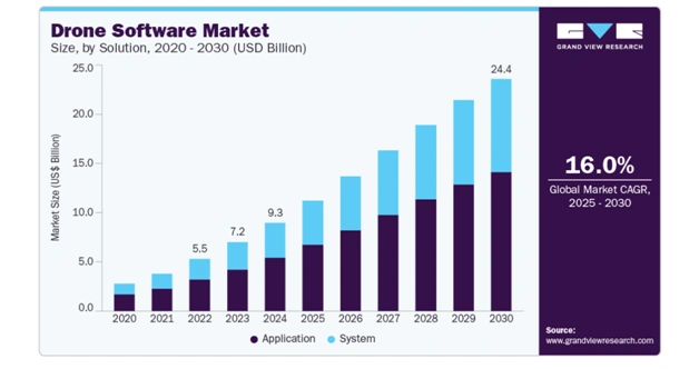
Source: Grandviewresearch
5 Reasons to Invest in Drone Tracker App Development
The drone industry has been booming recently, providing many avenues for entrepreneurs to invest in drone app development. Here are five reasons to consider this investment.
-
1. Solid Market Growth
According to Grand View Research, the global drone software market was valued at approximately USD 9.27 billion in 2024 and forecasted to reach USD 24.39 billion by 2030 at a CAGR of 16.0%. The anticipated market growth is driven by increased adoption in different sectors of industries such as agriculture, logistics, and defence.
Return rates will be via patrons of the drone tracker app development, so entrepreneurs are well-positioned to fight for the ever-expanding piece of the market pie.
-
2. Diverse Industry Applications
Drone tracker apps have a wide range of applications across industries:
- - Agriculture: Tracking the health of crops and managing resources better.
- - Logistics & Delivery: Making deliveries more secure and timely.
- - Healthcare: Delivering medical supplies to isolated places.
- - Emergency Services: Providing real-time situational awareness during disasters.
This variety makes it more valuable to drone tracker app developers in terms of a more significant potential customer base and revenue stream.
-
3. Advances in Technology
More advancements in drone technology, battery technology, AI, GPS, etc., make drone tracker apps more functional by providing more accurate tracking, real-time data analytics, and even autonomous tracking functions that will create even more value to drone tracker app users in all industries.
-
4. Government Support and Regulatory Developments
Governments worldwide are recognizing the full potential of drones and implementing policies, such as the recent reduction in Goods and Services Tax (GST) for drones, where commercial UAVs will be taxed at a 5% rate instead of the previously stated GST tax. Clearly, more support is being offered for drone technologies, and investment in drone apps is becoming easier.
-
5. High ROI
The rise in demand for drone services and adoption of drone technologies in other industries indicates a vast opportunity when it comes to return on investment with drone tracking apps.
While companies look for effective means to monitor and control drone use, developing specialty apps will offer valuable opportunities for monetization.
Types of Drone Apps
Before we take you through the process to create a drone tracker app, we want you to go through these amazing different types of drone applications.
Some of these are in the market, but some are still fresh ideas in the list of types of drone applications. So if you want to invest in this market in 2026, this is something you must save!
-
1. Drone Control Apps
These apps are helpful for directing the remote access of the drone. They outline the flight path, adjust the angle of the camera, and collect telemetry information. Providing a means for precise navigation of the drone ensures compliance with direction, safety, and executing safe tasks for stakeholder outcomes with precision across multiple fields of industry.
-
2. Drone Mapping & Surveying Apps
Drone-mapping apps often leverage drone imagery to organize data into 2-D mapping or 3D models for land surveys, construction planning, or agriculture clients. They optimize automated subsequent actions based on imagery to make actionable geospatial data efficiently.
-
3. Drone Delivery Apps
Drone delivery apps streamline and optimize automated deliveries of goods, medications, or packages with real-time tracking and identifying the shortest and alternate routes, by enabling secure location management capability through automated communications, limiting human delegation, and speeding up annotated communication mandated by the platform itself.
-
4. Drone Tracking & Fleet Management Apps
Fleet management and tracking apps focus on monitoring many drones at once. These apps keep watch for location, battery levels, operations status, and operational metrics designed to offer automation for logistics, agriculture, emergency services, and multiple drone deployment flights.
-
5. Drone Photography & Videography Apps
Drone photography apps allow for enhanced choices to utilize the drone’s capabilities, supporting filming, live streaming, and quality media content creation.
They provide camera control, flight stability, and creative features, along with various virtual enhancements.
-
6. Agriculture Drone Apps
Focused on precision farming, these apps help to monitor crop health, irrigation, soil health, and pest detection. They provide farmers access to actionable information that helps them improve yield, reduce cost, and adopt sustainable practices.
-
7. Emergency & Disaster Management Drone Apps
These apps help in search and rescue, disaster monitoring, and emergency responders by providing aerial real-time views, hazards insights, victim locations, and proper process mapping during rapid response for safe and organized rescue efforts.
-
8. Recreational Drone Apps
Developed for hobbyists, these apps provide features for casual flying, drone racing, and games. They made the flying experience easier, added social sharing capabilities, and provided new interactive experiences, while ensuring safety for leisure drone users.
6 Stages to Drone Tracker App Development
Developing a drone tracker app is a multi-tiered process that requires specialized knowledge, accuracy, and compliance with aviation standards.
Therefore, onboarding a professional GPS tracking app development company to deliver the deliverables helps maintain momentum through the product pipeline from product concept to launching your product. Below is a breakdown of the six stages:
-
1. Requirement Gathering & Market Research
The initial stage requires an understanding of the clients' requirements and researching the target market. The drone tracking company does deep research on applicable drone regulations, competitor apps, and user expectations.
At this stage, the drone tracking app development company would define the purpose for the app, whether it be for hobbyists, enterprise, or security agencies, and also draft a requirement gathering for functionality, including abilities for GPS tracking, geofencing, AI (if required), and real-time alerts.
-
2. Planning & Strategy Development
After requirements are established, the mobile app development company creates a roadmap detailing the technology stack (AI, IoT, cloud, GPS), budget, and timeframe. As the company develops wireframes and workflows to illustrate features, it considers drone laws (both local and international) and their functional requirements.
-
3. UI/UX Design
User interface (UI) experience is crucial in user adoption of performing real-time tracking and management of drones through an app. Professional designers create easy-to-use layouts, engaging dashboards, and concise navigation - making it easy for users to monitor their drones while still providing a fun experience. The design ensures features are simple yet powerful, function first, and are not cumbersome for users.
-
4. App Development & Integration
Moving to the fourth stage of GPS tracking app development, core functionalities include real-time GPS mapping, AI flight path prediction, obstacle detection, geofencing, and push notifications.
Developers will consider how IoT devices would integrate alongside the drone's hardware architecture and use 5G networks to ensure connectivity. Developers follow an agile methodology, and the app is continuously tested as it is developed to expedite cycles.
-
5. Testing & Quality Assurance
Before an app is launched, it is likely to undergo rigorous testing. QA teams assess bugs, security, and performance issues first. Repairing or addressing these concerns can be exacerbated with drone tracker apps due to their recursive nature.
Therefore, testing will also incorporate stress testing on the app's CPU, GPS accuracy, and the app's compliance with aviation standards. This phase provides developers with confidence that they can meet the requirement to provide a way for the app to perform continuously across devices and platforms.
-
6. Deployment & Ongoing Support
After testing is successful, the application is deployed and available for download in app stores and enterprise systems. The development company will also provide support, upgrades, new features, and maintenance. As both AI in drones regulations are changing rapidly, continual upgrades keep the app compliant, up to date, efficient, and competitive.
FAQ
-
How Does A Drone Tracker App Work?
By utilizing Bluetooth, Wi-Fi, or GPS signals to receive Remote ID broadcasts from registered drones, the application informs users of flight information.
-
Are Drone Tracker Apps Legal To Use?
Yes, in most places, provided they follow all local rules and regulations regarding privacy and airspace monitoring.
-
Can These Apps Detect All Drones?
The application is only able to detect drones transmitting Remote ID signals. Non-compliant drones may not be detected through the applications.
-
Do I Need Special Equipment To Use These Apps?
Typically, a smartphone or tablet (electronic device) with Bluetooth and Wi-Fi capabilities would be all you need to operate the majority of drone tracker apps.
Essential Features You Must Include in Your Drone Tracker App
Many of you must understand what we are going to discuss by reading the title, but stop there. This isn't any feature guide! This is the essential yet powerful feature list of the drone tracker app, which you must integrate into your upcoming 2026 drone controlling app investment.
-
1. Real-Time GPS Tracking
GPS tracking tracks the precise location of a drone in real time. This information improves route planning, geofencing, or just monitoring flight, which leads to increased safety, operational efficiencies, and better decision-making for a variety of industry uses.
-
2. Live Video Streaming
Enabling users to see live drone footage on mobile or web applications for surveillance, event coverage, crop monitoring or remote inspections, with minimal latency and high-quality video.
-
3. Flight Path Planning
Enables programming drone flight paths with waypoints, altitude, speed control, and allows for pre-programmed flight paths or ways for users to cover an area more efficiently with very little manual intervention.
-
4. Geofencing No Fly Zones
The best drone tracking apps allow users to restrict drones from entering restricted airspace by marking off virtual boundaries so they comply with FAA regulations, by notifying them when they are getting too close, and preventing them from flying into aircraft routes or military installations.
-
5. Obstacle Detection Avoidance
The drone GPS tracker app automatically detects and avoids obstacles using sensors and AI algorithms. Acts on its own to avoid collateral damage or injury, making drones safe for commercial use in complex environments.
-
6. Battery Performance Monitoring
The drone tracker app for Android displays current battery levels and health information regarding drone performance indicators, to help avoid sudden failures or downtime. Battery monitoring options can assist in extending mission time for a seamless operation.
-
7. Data Analytics Reporting
Collects flight data and operational metrics that can be evaluated for performance and predictive maintenance reporting. Provides insights that are actionable to improve efficiency and reduce operational costs.
-
8. Push Notifications Alerts
Push notifications for anything from low battery, route deviations, weather alerts, to maintenance reminders, keep users aware of drone status, and provide some controls for drone management.
-
9. Integration with Cloud Storage
Flight data, video, and telemetry can be stored on the cloud for safekeeping, safe access, sharing, and historical analysis across multiple device options and stakeholders or users.
-
10. Multi-Drone Management
The drone tracker app for iPhone enables control and monitoring of multiple drones simultaneously to optimize logistics, agriculture, surveillance, and disaster management of large-scale operations.
-
11. AI Object Detection
Detects objects, animals, or people using AI, improving surveillance, analytical capabilities on crops, and supervision of safety while drones are operating.
-
12. Weather Monitoring & Alerts
The app for tracking drones provides current weather information and alerts, giving clarity on whether it is safe to fly by avoiding weather-related accidents during operating conditions.
-
13. Customizable Dashboard
Provides a user-friendly interface to monitor drone metrics, flight paths, and analytics while enabling users to customize their dashboard experience, making drone management as efficient as possible.
-
14. Remote Control via Mobile or Web
Allows users to fly/operate their drones from a mobile device or desktop, providing flexibility and convenience, and the capability to operate drones from virtually anywhere.
-
15. Regulatory Compliance Capabilities
The application automatically checks to see if airspace rules are violated, management checks to obtain flight permission and/or restrictions to make sure the drone operates safely and legally. This reduces liability and validates operational capability.
What Are the Guidelines for Built Drone Control Applications?
When you create a mobile app for drone tracking, consider the target objectives and focus on the particular industry. Ensure you have real-time GPS tracking, the ability to plan flight paths, and geofencing capabilities to protect you from both safety and regulatory perspectives. You may also want to consider having live video streaming capabilities, the ability to avoid collision or deconflict, and return to home automated flight capability. Implement secure user authentication, role-based access, and encryption of sensitive data to reduce risk. Utilize cloud storage and analytics to store flight logs and provide insights into drone performance. Conduct tests in both simulated and real-world environments, optimize for battery life, and consider scalability to easily manage rockets or fleets of drones.
Drone Tracker App Development: Changing These Revenue-Generating Industries
This is the most crucial aspect, or you can say a thought runs in the mind of many existing entrepreneurs running different businesses. We get what you're thinking about, and that's why we are here with solutions. To all the businesses wondering “how drones are going to help my business,” we have. So in this section, we have covered it for you!!!!!
-
1. Drone Tracker in Retail & E-commerce: Use Case
Drone tracker in retail improves inventory management, warehouse monitoring, and last-mile delivery for retail and e-commerce industries. The benefit of drone tracker apps in e-commerce industries is that they provide real-time tracking of drones, allowing businesses to ensure that products move through their supply chain on time and avoid delays caused by humans. Additionally, drone tracker apps also allow businesses to have better visibility into stock levels located in warehouses or distribution centers, which can positively impact inventory management and help improve operational efficiency.
-
2. Drone Tracker in Logistics & Delivery: Use Case
In the logistics space, drone tracker apps track shipments and fleet drones in delivery. Drone tracker in logistics also provides businesses with drone location and delivery route optimizations, and delivery status updates in real-time. The application of drone tracker apps in logistics provides businesses with benefits like reduced operational costs, information to avoid delays, and the creation of plans to prevent items from being lost or damaged during transit. Businesses can also better incorporate last-mile delivery for both urban areas and remote locations.
-
3. Drone Tracker in Agriculture: Use Case
Drone tracking in agriculture allows farmers to monitor crop health, soil quality, and irrigation systems in real-time. Equipped with GPS capabilities, drones can take overhead photos and video footage, while also being able to identify areas of pest infestation, water stress, or nutrient deficiency. As a result, farmers can more effectively manage fertilizer and pesticide usage, reduce labor costs, and improve crop yield. Drone tracking apps provide real-time updates that enhance farm management efficiency and sustainable farming practices, and better emphasize action for decision-making in precision agriculture.
-
4. Drone Tracker in Healthcare: Use Case
Drone tracking in healthcare is an essential tool for healthcare systems as they track medical drone deliveries for vaccines, medicines, and lab samples. Tracking in real-time ensures safe and efficient transportation and delivery to hospitals, clinics, or remote areas. This reduces reliance on traditional means of transport, decreases time, and ultimately enhances emergency response levels, and provides hospitals, clinics, and remote locations with critical supplies in the correct location at the right time. Couple this service with a healthcare logistics system used to manage healthcare resources, and hospitals can also keep track of their inventories.
-
5. Drone Tracker in Emergency Services: Use Case
Drone tracking in emergencies provides assistance to emergency service responders when dealing with natural disasters, accidents, or search and rescue operations. In these situations, drones enhance how responders and emergency services assess the ground situation through aerial real-time footage. These capabilities also help to find victims, locate people, assess damages, and plan intervention tactics or strategies. According to the ML development company, drone tracking apps facilitate enhanced situational awareness, helping to provide an effective and timely response to emergency or disaster operations. It can increase effectiveness in search and rescue endeavours while reducing risks associated with human personnel.
-
6. Drone Tracker in Advertising & Marketing: Use Case
Drone tracker in marketing provides help to Marketing Agencies with high-quality aerial content for promotions, product launches, and brand campaigns. Real-time geographic coordinates lead to accurate positioning for camera angles, and this efficient filming translates into impressive footage for the client. Drones can shoot large events in a way that is dynamic, capturing the audience experience as well as the action. Tracking ensures that operations are efficient and compliant with safety protocols, that the product will reflect an unprecedented marketing opportunity to establish a differentiating platform content to engage consumer audiences and improve brand awareness itself.
-
7. Drone Tracker in Entertainment, Media & Sports: Use Case
Drone tracker applications provide Fleet Management support for Filmmakers, Broadcasters, and Sports Organizations with time and resource-efficient options to capture aerial footage and live coverage quality. Real-time user visibility provides optimum positioning to manage smooth movements while relating to crowd or event transit and engagement. Drones in sports provide a unique perspective, allowing real-time analysis of athlete performance as well as audience participation and experience. These drone tracking applications help reduce filming costs for the organizations while adding value for audience experience factors.
-
8. Drone Tracker in Event Management: Use Case
Drone tracker in event management adds value to support event organizers by monitoring crowd movement, security, and event logistics overall. Real-time tracking offers aerial coverage of an event to help organizers manage venue layouts, review crowd congestion, and crowd units to manage staff actions effectively and without risk. In addition, participants can create live coverage to be marketed or used as a virtual attendance option for the event. When using drone tracking for crowd management at large events, organizers are able to keep participants safe, improve operational efficiency, and provide participants with insights to optimize their event experience based on access to real-time information.
-
9. Drone Tracker in Traffic & Transportation: Use Case
Drone tracker in transportation for traffic management allows real-time awareness of vehicle movements, congestion, incidents, etc. When transportation authorities have visibility into their traffic, they can identify patterns in overall traffic, identify traffic violations, and manage emergency responses. Drones can be used to monitor highways & roadways, intersections, and public transportation routes. Tracking provides control, better road safety, and helps see potential urban planning needs. Real-time traffic monitoring provides predictive traffic management and data-driven decisions to improve the effectiveness of the transportation infrastructure.
-
10. Drone Tracker in Manufacturing: Use Case
Drone tracker in manufacturing monitors production facilities, warehouses, and supply chains. Drones are used to monitor the movement of materials, identify safety risks, and keep equipment or infrastructure under surveillance in real time. Drone tracker apps support a reduced manual inspection burden, increased operational efficiencies, and adherence to safety regulations. Tracking materials and real-time analytics creates opportunities for proactive maintenance, quality assurance, and workflow improvements for manufacturers that can lead to enhanced productivity in addition to lower costs across the entire drafting process.
What Are the APIs and SDKs for Drone Tracker App Development?
As a business investor, it is important for you to understand different APIs for real-time information and SDKs for development. Here, we will focus on them with the help of a table with a detailed description for each:
| PI/SDK | Purpose | Industry Use Cases |
|---|---|---|
| DJI SDK | Provides drone control, live video streaming, telemetry data, and flight path management. | Logistics, Agriculture, Media & Entertainment, Emergency Services |
| Google Maps API | Real-time mapping, route plotting, geofencing, and location services. | Logistics, Traffic & Transportation, Retail & E-commerce |
| Mapbox SDK | Customizable maps, navigation, and location tracking. | Agriculture, Event Management, Tourism |
| AirMap API | No-fly zone alerts, flight authorization, and airspace safety compliance. | Aviation, Defense, Emergency Services |
| OpenDroneMap | Converts drone images into maps, 3D models, and geospatial data. | Agriculture, Construction, Manufacturing |
| AWS IoT & AWS Lambda | Real-time drone telemetry, cloud data storage, and processing. | Healthcare, Logistics, Traffic Monitoring |
| Microsoft Azure Maps | Geospatial analytics, route optimization, and traffic monitoring. | Transportation, Urban Planning, Insurance |
| Pix4D SDK | Aerial photogrammetry, mapping, and 3D modeling from drone images. | Agriculture, Construction, Real Estate |
| DroneDeploy API | Flight planning, live tracking, and data analytics dashboards. | Agriculture, Manufacturing, Surveying |
| Telemetry APIs | Access to altitude, speed, battery status, and GPS data. | All industries using UAVs for operational insights |
Success Story of DedroneTracker.AI
Launched in July 2023, DedroneTracker.AI is an AI-powered drone detection and countermeasure platform. Co-founded by Ingo Seebach in 2014, Dedrone has developed an international presence, protecting more than 955 sites globally. The platform leverages sensor fusion to automatically identify and classify drone threats from RF, radar, video,and acoustic sensor data. The company had a run rate of $27.3 million in 2023, demonstrating the level of adoption in the marketplace.
How Much Does it Cost to Build a Drone Tracker App?
The cost to develop a drone tracker app can vary due to numerous variables. The average cost to create a drone track app could range from $8,000 to $25,000 or more, depending on complexity, features, and development team location and experience.
Important factors to consider:
-
App Complexity
Basic apps that only include flight control and streaming live video will cost less than an app that claims object detection, real-time data, etc. AI to help analyze streams of data and make decisions based on that data will take longer and a higher drone tracker app development cost.
Component Estimated Cost Range Basic Features $8,000 – $12,000 Moderate Features $12,000 – $20,000 Advanced Features $20,000 – $30,000 -
Platform
Developing on more than one platform (IOS or Android) will incur a waiting period due to platform-dependent development. However, if you use a platform, the cost to develop a drone tracker app will be lower. Native apps typically have a higher cost to develop a GPS tracking software.
Component Estimated Cost Range iOS App $8,000 – $15,000 Android App $8,000 – $15,000 Cross-Platform App $15,000 – $25,000 -
Development Team Location
Hourly rates vary between regions. For example, developers may charge $50-$250 per hour in the US, $30-$150 in Eastern Europe, and $10-$25 in India. Some developers have a higher experience level, which can raise the cost to build a drone tracker app.
Location Estimated Cost Range North America (USA/Canada) $25,000 – $30,000 Western Europe (UK, Germany, France) $20,000 – $28,000 Eastern Europe (Poland, Ukraine, Romania) $15,000 – $22,000 India $8,000 – $15,000 Southeast Asia (Philippines, Vietnam, Indonesia) $10,000 – $16,000 South America (Brazil, Argentina, Chile) $12,000 – $18,000 Middle East (UAE, Saudi Arabia) $18,000 – $25,000 -
UI/UX Design
A high-level user interface and user experience design can increase Android app development costs. An easier-to-use, visually pleasing UX will take longer to design and develop.
Component Estimated Cost Range Basic UI $8,000 – $12,000 Custom UI/UX $12,000 – $18,000 Advanced Design $18,000 – $25,000 -
Third-Party Integrations
Implementing third-party APIs/SDKs (for example, connecting to the DJI SDK for drone control, or mapping services) may increase the drone tracker app development cost due to required licensing fees and implementation time needed.
Component Estimated Cost Range GPS & Mapping APIs $8,000 – $12,000 Cloud Storage $12,000 – $18,000 Payment Gateway $15,000 – $20,000 -
Maintenance and Updates
Maintenance, updates, bug fixes, and server costs in the post-launch phase usually account for 15%-20% of the original geolocation app development cost annually.
Component Estimated Cost Range (per year) Bug Fixes & Patches $8,000 – $10,000 Security Updates $10,000 – $12,000 Feature Upgrades $12,000 – $18,000 Performance Optimization $15,000 – $20,000
The cost to develop a drone tracker app involves a number of elements, including the complexity, whether the app will be web-based or mobile, the country where the drone tracker app development company is located, design and user experience, third-party integrations, and the time and costs required for maintenance. All of these elements need to be carefully considered and discussed with experienced developers if you want an affordable cost to develop a drone tracker app.
How Does a Drone Tracker App Generate Revenue?
Now that you know the drone tracker app development cost, you must be wondering about how to earn money. A Drone Tracker App will not only provide safety and effective drone monitoring but can also be a profitable entrepreneurial venture.
Here are five key ways it can generate revenue:
-
1. Subscription Plans
The most typical revenue model would be to offer subscriptions. With subscription models, users would access the basic feature for free, but if they wanted advanced features like AI-driven tracking, geofencing, analytics, and flight history storage, they could opt for a monthly or yearly premium plan. Subscription services can offer the advantage of recurring revenue and keeping customers in the ecosystem for the long haul.
-
2. Freemium Model with In-App Purchases
Many apps utilize a freemium model that allows basic access for free, but would require in-app purchases for additional features, like advanced flight reports, customizable alerts, or the option to store cloud data for longer periods of time. The benefit of the freemium model is that it allows you to capture larger amounts of users while at the same time monetizing the power users to generate more revenue through add-on capabilities.
-
3. Enterprise & Industry Solutions
Businesses in logistics, agriculture, surveillance, and defense rely on drones for their operation. If businesses build an app like DroneDeploy, it provides enterprise solutions with bulk tracking, integration with IoT/ERP systems, and data analytics capabilities, creating high-value opportunities with a business-to-business revenue model. Offering customized packages based on industry could provide a valuable revenue stream.
-
4. Advertising and Partnerships
Drone tracker apps can partner with drone manufacturers, insurance companies, and hardware providers. By allowing the app to display relevant advertising or promote drone-related products, this can generate advertising revenue. Value can also be realized through strategic partnerships that offer opportunities for co-branding and sponsorships.
-
5. Data Monetization and Insights
By using a drone tracking app, the insights collected can provide compensation and value. For example: flight patterns, geographic area usage, and density/demand for drones, regionally and seasonally. This data, anonymized and aggregated, could be sold to industries, governments, or research institutions for urban planning, security, and airspace management, providing yet another revenue stream.
How Dev Technosys Can Assist in Drone Tracker App Development?
Dev Technosys is the best partner for Drone Tracker App solutions, with 15+ years of experience creating innovative, technology-focused projects in multiple industries. Our world-class hybrid app development company will ensure your business is sound, with AI, GPS, and real-time tracking fully integrated to accomplish your business objectives. Our focus is on developing a scalable, secure, and user-friendly solution that will enhance operational control and decision-making. Dev Technosys has a proven process to develop solutions in logistics, agriculture, healthcare, and more. With a combination of industry knowledge, technical excellence, and dedicated support, Dev Technosys can enable your business to unleash the full potential of drone business value.
Frequently Asked Questions
-
Which Industries Would Most Benefit From Drone Tracker Apps?
Drone tracker applications are revolutionising the logistics, agriculture, healthcare, emergency, and entertainment industries by providing real-time tracking, route optimization, and operational visibility, which will increase efficiencies, safety, and productivity in a variety of sectors.
-
How Do Drone Tracker Apps Ensure Flight Safety?
As drone tracking apps integrate GPS, real-time alerts, and geofencing, they avoid collisions, alert drones in restricted spaces, and offer off-the-cuff notifications. Drone tracker apps operate a safety net to function safely, legally, and responsively.
-
Can Drone Tracker Apps Influence Delivery Paces?
Yes! Drone tracker apps have the features to track in real-time, automatically optimize delivery routes, and offer performance analytics to offer timely, reliable deliveries while applying operational efficiencies, reducing costs, and improving customer experience in the e-commerce and logistics sectors.
-
What Features Should Be Included In A Drone Tracker App To Stand Out?
Advanced GPS tracking capabilities, AI-powered mapping and reporting, live video streaming, geofencing, and predictive maintenance are needed for drone tracking apps to be innovative, integrated, and essential in maximizing how businesses that rely on UAV operations operate.
-
Why Should New Venture Entrepreneurs Consider Investing In Drone Tracker App Development?
Demand is expected to grow, ultra-expanded use cases, and government support make drone tracking apps a viable target for entrepreneurs invested in growth to invest in, offering scale, opportunity for ROI, and competitive advantage in this rapidly growing drone tracking sector.